Dangyang
County-level city in Hubei, People's Republic of China From Wikipedia, the free encyclopedia
Dangyang (simplified Chinese: 当阳; traditional Chinese: 當陽; pinyin: Dāngyáng) is a city in western Hubei province, People's Republic of China, lying 70 kilometres (43 mi) east of the Gezhouba Dam on the Yangtze River. During the Western Han dynasty (206–24 BC). Emperor Jing of Han established an administration in Dangyang on an area of 2,000 square kilometres (770 sq mi). In 1988 the State Council of the People's Republic of China elevated this from a county to a county-level city, and is currently under the administration of the prefecture-level city of Yichang.[1]
This article needs additional citations for verification. (August 2016) |
Dangyang
当阳市 Tangyang | |
|---|---|
 Dangyang Yuquan Temple | |
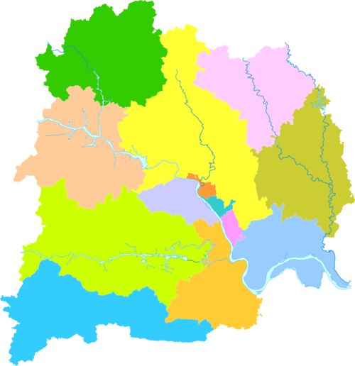
 Dangyang is the easternmost division on this map of Yichang | |
| Coordinates: 30°49′16″N 111°47′20″E / 30.821; 111.789][[Category:Pages using gadget WikiMiniAtlas]]"},"html":"Coordinates: </templatestyles>\"}' data-mw='{\"name\":\"templatestyles\",\"attrs\":{\"src\":\"Module:Coordinates/styles.css\"},\"body\":{\"extsrc\":\"\"}}'/>30°49′16″N 111°47′20″E / 30.821°N 111.789°E"}"> | |
| Country | People's Republic of China |
| Province | Hubei |
| Prefecture-level city | Yichang |
| Area | |
| 2,038 km2 (787 sq mi) | |
| • Urban | 220.30 km2 (85.06 sq mi) |
| Population (2020)[3] | |
| 397,465 | |
| • Density | 200/km2 (510/sq mi) |
| • Urban | 224,057 |
| Website | hbdy |
Dangyang used to be a strategic point in ancient wars. Sun Bin and Pang Juan, two famous strategists of the Warring States period (475–221 BC) studied military affairs from Gui Guzi at Daxian Cave in Dangyang. The Green Woods Uprising was launched in Dangyang and several battles were fought in Dangyang during the Three Kingdoms period (AD 220–280).
Today Dangyang is a rapidly growing modern city with a population of over 100,000. While agriculture remains a key industry in Dangyang, industrial production now includes output in the areas of foodstuffs, building materials, textiles, chemicals, electronics, machinery, energy and packaging.
On August 11, 2016, an explosion at a chemical factory in Dangyang killed 21 people and injured at least 5.[4]
Administrative divisions

Seven towns:
Climate
| Climate data for Dangyang, elevation 92 m (302 ft), (1991–2020 normals) | |||||||||||||
|---|---|---|---|---|---|---|---|---|---|---|---|---|---|
| Month | Jan | Feb | Mar | Apr | May | Jun | Jul | Aug | Sep | Oct | Nov | Dec | Year |
| Mean daily maximum °C (°F) | 8.5 (47.3) |
11.6 (52.9) |
16.5 (61.7) |
22.7 (72.9) |
27.2 (81.0) |
30.1 (86.2) |
32.4 (90.3) |
32.2 (90.0) |
28.4 (83.1) |
23.0 (73.4) |
16.8 (62.2) |
10.9 (51.6) |
21.7 (71.1) |
| Daily mean °C (°F) | 4.3 (39.7) |
6.9 (44.4) |
11.4 (52.5) |
17.2 (63.0) |
22.0 (71.6) |
25.6 (78.1) |
28.0 (82.4) |
27.6 (81.7) |
23.5 (74.3) |
17.9 (64.2) |
11.9 (53.4) |
6.4 (43.5) |
16.9 (62.4) |
| Mean daily minimum °C (°F) | 1.3 (34.3) |
3.4 (38.1) |
7.4 (45.3) |
12.9 (55.2) |
17.8 (64.0) |
21.9 (71.4) |
24.6 (76.3) |
24.1 (75.4) |
20.0 (68.0) |
14.4 (57.9) |
8.5 (47.3) |
3.2 (37.8) |
13.3 (55.9) |
| Average precipitation mm (inches) | 24.3 (0.96) |
31.8 (1.25) |
54.4 (2.14) |
89.2 (3.51) |
138.1 (5.44) |
144.9 (5.70) |
178.6 (7.03) |
137.8 (5.43) |
75.7 (2.98) |
71.6 (2.82) |
40.3 (1.59) |
14.3 (0.56) |
1,001 (39.41) |
| Average precipitation days (≥ 0.1 mm) | 7.1 | 8.2 | 10.8 | 11.8 | 12.7 | 11.7 | 12.5 | 10.2 | 9.1 | 10.1 | 8.4 | 6.4 | 119 |
| Average snowy days | 3.7 | 2.5 | 1.1 | 0 | 0 | 0 | 0 | 0 | 0 | 0 | 0.3 | 1.6 | 9.2 |
| Average relative humidity (%) | 71 | 71 | 72 | 74 | 73 | 78 | 80 | 77 | 73 | 74 | 75 | 71 | 74 |
| Mean monthly sunshine hours | 77.1 | 83.2 | 117.3 | 137.2 | 144.5 | 137.3 | 175.7 | 184.6 | 138.3 | 127.9 | 109.0 | 92.3 | 1,524.4 |
| Percentage possible sunshine | 24 | 26 | 31 | 35 | 34 | 33 | 41 | 45 | 38 | 37 | 35 | 29 | 34 |
| Source: China Meteorological Administration[8][9] | |||||||||||||
References
External links
Wikiwand - on
Seamless Wikipedia browsing. On steroids.
