Kranichfeld
Town in Thuringia, Germany From Wikipedia, the free encyclopedia

Kranichfeld is a town in the Weimarer Land district, in Thuringia. It is situated on the river Ilm, 18 km southeast of Erfurt, and 16 km southwest of Weimar.
Kranichfeld | |
|---|---|
 Coat of arms | |
Location of Kranichfeld within Weimarer Land district 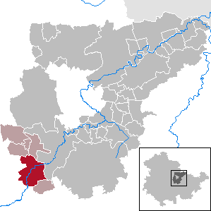 | |
 Kranichfeld  Kranichfeld | |
| Coordinates: 50°51′N 11°12′E / 50.850; 11.200][[Category:Pages using gadget WikiMiniAtlas]]"},"html":"Coordinates: </templatestyles>\"}' data-mw='{\"name\":\"templatestyles\",\"attrs\":{\"src\":\"Module:Coordinates/styles.css\"},\"body\":{\"extsrc\":\"\"}}'/>50°51′N 11°12′E / 50.850°N 11.200°E"}"> | |
| Country | Germany |
| State | Thuringia |
| District | Weimarer Land |
| Municipal assoc. | Kranichfeld |
| Subdivisions | 3 |
| Government | |
| • Mayor (2022–28) | Jörg Bauer[1] |
| Area | |
• Total | 23.08 km2 (8.91 sq mi) |
| Elevation | 301 m (988 ft) |
| Population (2022-12-31)[2] | |
• Total | 3,313 |
| • Density | 140/km2 (370/sq mi) |
| Time zone | UTC+01:00 (CET) |
| • Summer (DST) | UTC+02:00 (CEST) |
| Postal codes | 99446–99448 |
| Dialling codes | 036450 |
| Vehicle registration | AP |
| Website | www.kranichfeld.de |
History
Within the German Empire (1871-1918), Kranichfeld was part of the Grand Duchy of Saxe-Weimar-Eisenach.
References
Wikiwand - on
Seamless Wikipedia browsing. On steroids.